Savannah Way Road Trip | Cairns To Broome
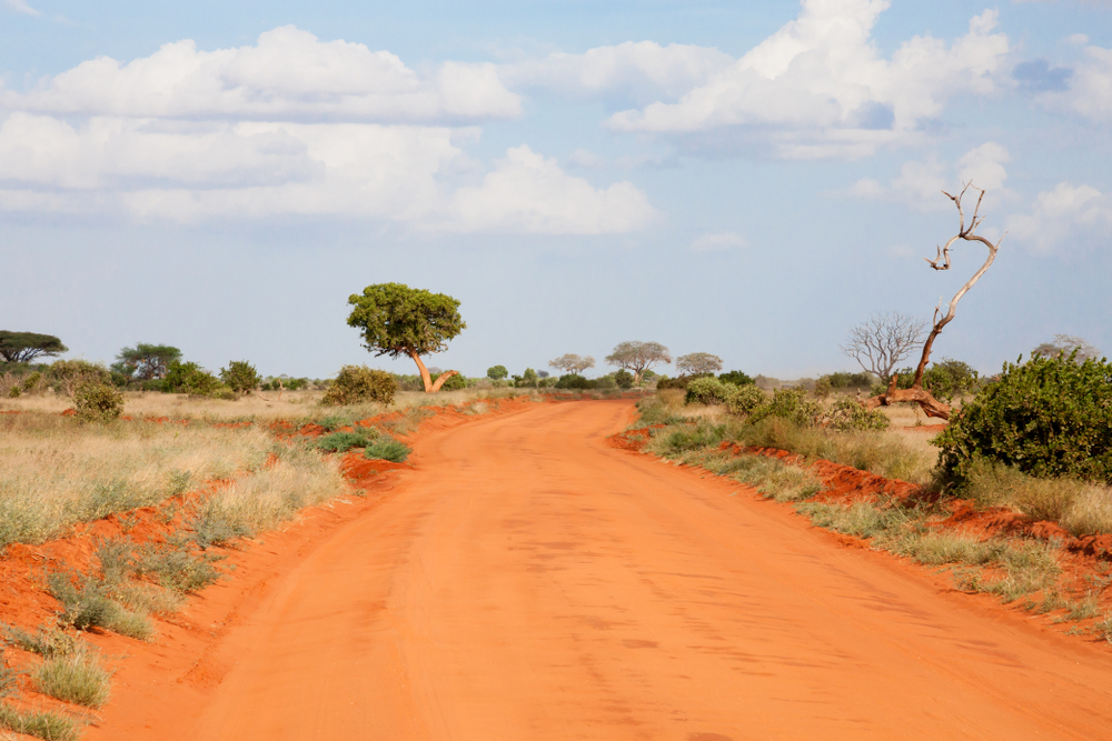
The Savannah Way stretches approximately 3,700 kilometres across the top of Australia, linking Cairns in tropical Far North Queensland with Broome in Western Australia's Kimberley region. Depending on your chosen route and any detours, driving the full way takes most travellers between 14 and 21 days, though plenty of people tackle it in shorter sections.
The journey crosses Queensland’s Gulf Country, the Northern Territory and the Kimberley. Predominantly sealed alternatives are available for some stages, while parts of the direct route and several popular detours may require high clearance, four-wheel-drive capability or an off-road-ready RV setup.
This guide covers the main route regions, suggested stops, seasonal timing, caravan and motorhome considerations, and the checks to complete before travelling through remote northern Australia.
What Should You Know Before Driving the Savannah Way Route?
Much of the Savannah Way runs through remote country, where rain, flooding or roadworks can quickly change the trip. Settle on your route before leaving, then check the latest road and park updates. Make sure you have enough fuel and water for the longer stretches, and that your vehicle is up to the roads you plan to take.
Planning item | Guidance |
Total distance | Approximately 3,700 km from Cairns to Broome. |
Suggested duration | 14-21 days for the full route one-way |
Best general travel period | April to October, subject to current road, weather and park conditions. |
Regions covered | Far North Queensland, Gulf Country, Northern Territory and The Kimberley. |
Key stops | Cairns, Normanton, Karumba, Borroloola, Katherine, Kununurra, Halls Creek, Fitzroy Crossing, Derby and Broome. |
Road surfaces | Mix of sealed highway, dirt road and remote sections – check conditions before you go. |
RV suitability | Depends on the chosen alignment, current conditions and the specifications of the vehicle, caravan or motorhome. |
Essential checks | Road reports, weather, park access, fuel, water, bookings, insurance and vehicle limits. |
***Road conditions, fuel availability, park access and weather can change without notice. Confirm current information with road authorities, park agencies and local visitor centres before travelling. Always follow vehicle, caravan, towing and insurance requirements for your chosen route.***
What Is the Savannah Way?
The Savannah Way is a self-drive tourist route that crosses Australia's tropical north. It connects five UNESCO World Heritage sites, passes through multiple national parks, remote outback towns and runs through some of the most dramatic landscapes in the country – from the Gulf Savannah country of Queensland to the red gorges of the Kimberley.
The route links Queensland to Western Australia via the Northern Territory, including stops at Cairns, Normanton, Borroloola, Katherine, Kununurra, Fitzroy Crossing, Derby and Broome. Most RV travellers follow major highways, including the Gulf Developmental Road, Barkly Highway, Victoria Highway, and Great Northern Highway, with optional detours adding off-road adventure along the way.
It is not a single sealed highway from start to finish, so it's important to understand which sections are suitable for your RV or caravan setup. Road surfaces vary significantly depending on which section you are on, recent weather and the time of year. The dry season from April to October generally provides the most reliable conditions, particularly on unsealed sections.
Savannah Way Map and Main Route Options
The Savannah Way crosses Queensland, the Northern Territory and Western Australia between Cairns and Broome. The map below shows the main touring corridor, major stops and selected detours to help you understand the overall route before planning each stage.
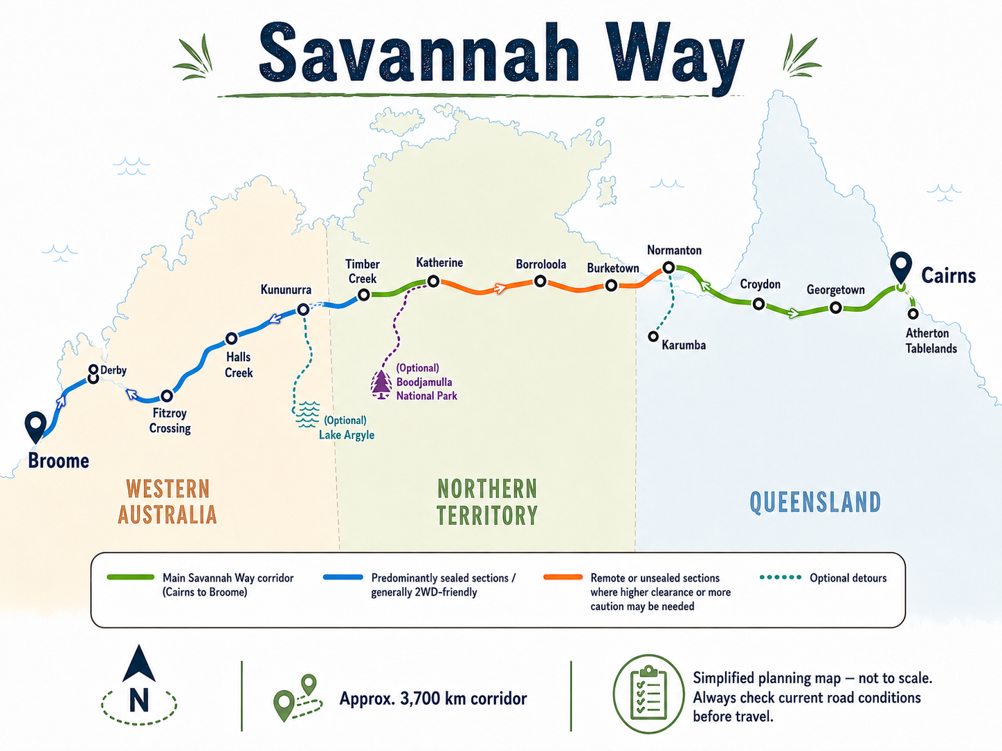
Map note: This is a simplified route overview and is not to scale. Road surfaces, access and vehicle suitability can change. Check the official Savannah Way map and current state road reports before travelling.
Official map link: View the official Savannah Way maps and touring guides.
Suggested 14-21-Day Savannah Way Itinerary
The Savannah Way can be completed in about two weeks, but a 21-day itinerary gives travellers more time for national parks, fishing stops, rest days and changing road conditions. The stages below are a flexible planning framework rather than a fixed schedule.
Suggested stage | Overnight base | Main purpose | Planning note |
Days 1-2 | Cairns or Atherton Tablelands | Prepare, stock supplies and explore the tropical highlands | Complete vehicle, tyre, fuel and water checks |
Days 3-4 | Georgetown or Croydon | Break up the Gulf Developmental Road journey | Confirm fuel opening hours and road conditions |
Days 5-6 | Normanton and Karumba | Explore Gulf history, fishing and sunsets | Karumba is a detour from the westbound route |
Days 7-8 | Burketown or the Boodjamulla area | Explore Gulf Country and national park landscapes | Boodjamulla access may include unsealed roads |
Days 9-10 | Borroloola or selected NT stop | Enter the NT and reassess route conditions | Confirm the route to Katherine before departure |
Days 11-12 | Katherine | Resupply and visit Nitmiluk National Park | Use Katherine as a major fuel, food and water stop |
Days 13-14 | Kununurra | Enter the Kimberley and explore Lake Argyle | Check WA border and biosecurity requirements |
Days 15-16 | Halls Creek | Break the long Kimberley stage | Confirm fuel and accommodation availability |
Days 17-18 | Fitzroy Crossing | Explore the Fitzroy Valley | Check current access to parks and gorge areas |
Days 19-20 | Derby | Visit local attractions or suitable off- road detours | Bandilngan and Dimalurru require separate access planning and are not stops on the sealed main route. |
Day 21 | Broome | Complete the journey | Allow extra nights for Cable Beach and Broome attractions |
Queensland: Cairns to the NT Border
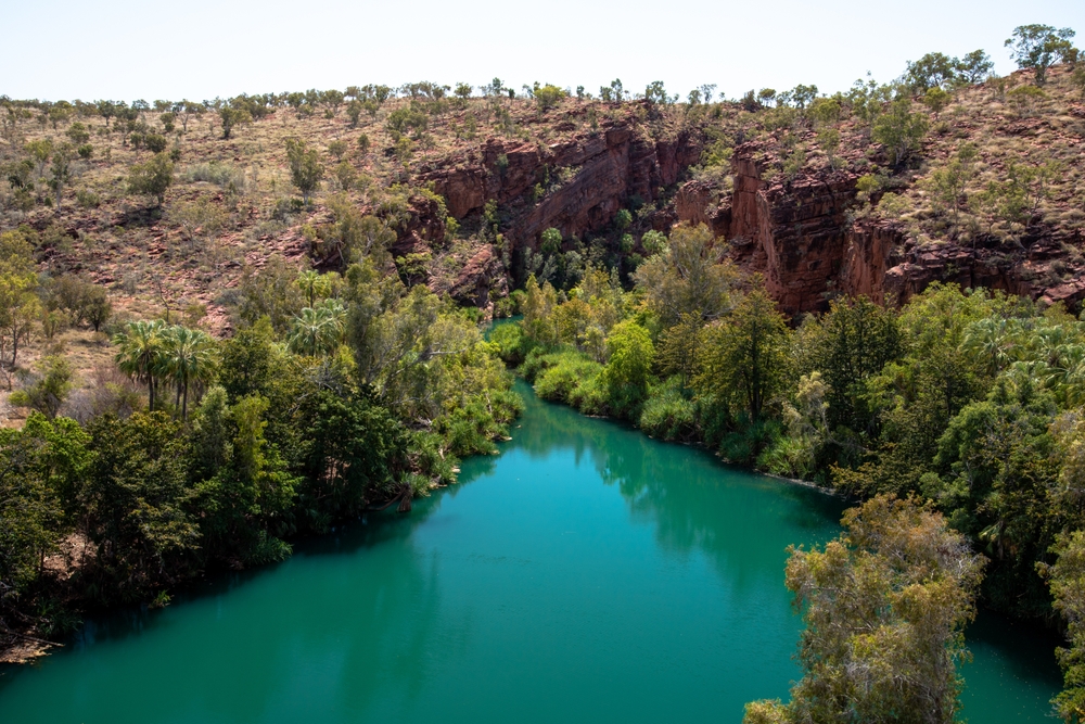
Lawn Hill Gorge
The Queensland section runs from Cairns through the Atherton Tablelands and Gulf Country before reaching the Northern Territory border. Most travellers divide it over several days, with practical stops in or around Georgetown, Croydon, Normanton, Karumba, and Burketown.
Road surfaces and access can vary west of Normanton, particularly on side trips to Boodjamulla National Park. Confirm the chosen route and current conditions before leaving each major service town.
Leaving Cairns, the route heads inland and north-west through Atherton, Mount Garnet and Croydon before reaching the Gulf town of Normanton. This stretch introduces travellers to the wide-open Queensland outback, remote road conditions, and a landscape that leaves the coastal sub-tropics far behind.
Normanton’s National Hotel, commonly known as the Purple Pub, is one of the town’s best-known landmarks and a convenient meal stop. The town is also home to Krys the Croc, an 8.63-metre fibreglass replica of what was reported to be Australia's largest saltwater crocodile, although the original animal's recorded size has never been independently verified.
From Normanton, it's worth the short detour north to Karumba, a fishing town at the mouth of the Norman River with caravan parks, supplies and spectacular Gulf sunsets. The Les Wilson Barramundi Discovery Centre and Hatchery is another popular stop, offering guided tours and a chance to learn about the Southern Gulf barramundi breeding program, with dedicated parking for larger RVs. If the Gulf Country leaves you wanting to see more, our Ultimate Outback Queensland Road Trip Guide covers additional outback towns, landscapes and touring routes across Queensland.
Continuing west, the route passes through Burketown and the Lawn Hill Gorge area within Boodjamulla National Park before reaching the Northern Territory border. Known for its fire-red sandstone gorges and emerald-coloured waters, Boodjamulla is one of the most popular detours on the Savannah Way for canoeing, hiking to lookouts and a visit to the UNESCO-listed Riversleigh Fossil Fields.
Caravan tip: Access to Boodjamulla National Park includes unsealed roads. Check current road conditions before travelling and ensure your vehicle and setup are suitable for the conditions.
Northern Territory: Gulf to Katherine
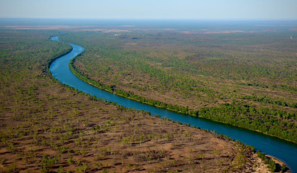
McArthur River
The Northern Territory section requires careful route planning because the most direct route may involve remote, unsealed roads. Travellers using conventional caravans or lower-clearance motorhomes should compare the direct route with longer sealed alternatives before leaving the Gulf region.
Once across the Northern Territory border, the route passes through Borroloola, a remote town on the McArthur River known for its fishing and outback character. Borroloola is an important place to check fuel availability, local road advice and the condition of the next planned section. Do not rely solely on standard navigation estimates, particularly after wet-season damage or recent roadworks.
Before you leave Borroloola, decide which route you are taking and check that it suits your vehicle. Some options are more remote, while the mostly sealed alternatives can mean a longer drive. Look at the latest road reports and consider your fuel range, vehicle clearance, towing setup and experience before choosing.
The route continues west toward Katherine, one of the most important service towns on the trip. Katherine has full facilities for caravanners: fuel, water, dump points, supermarkets and multiple caravan parks. Fill up and stock up here before continuing west.
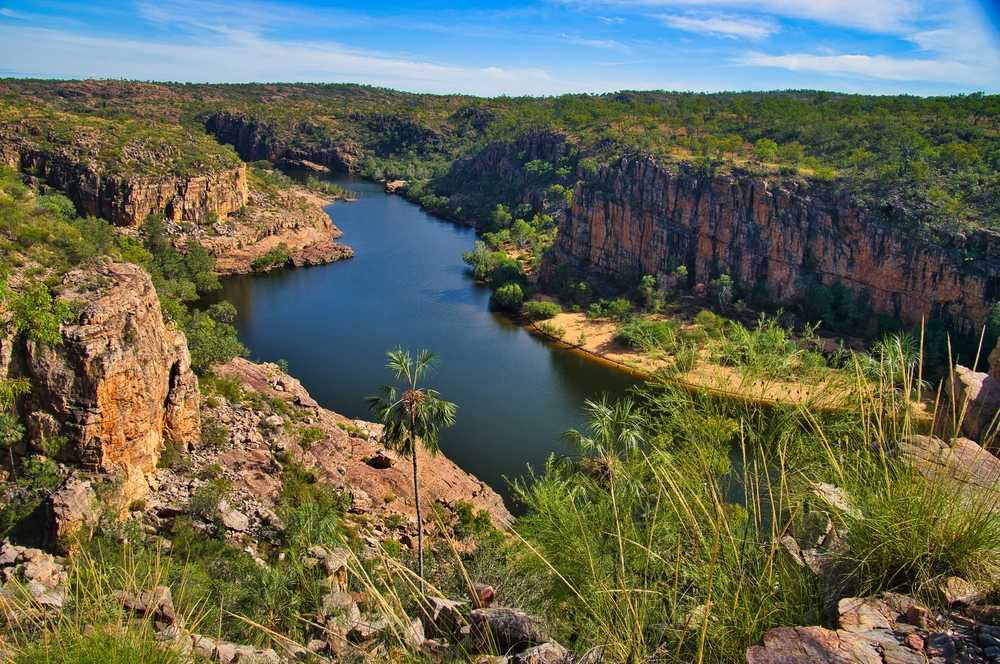
Katherine Gorge
Nitmiluk (Katherine Gorge) National Park is right on the doorstep and is home to 13 sandstone gorges carved by the Katherine River. Accessible by canoe, walking track or cruise, the park has excellent campgrounds if you want to spend a couple of nights.
Caravan tip: Katherine is a key resupply point, so when heading west, don’t skip it! Fuel and services become less frequent on the NT-WA border stretch.
Western Australia: Kununurra to Broome
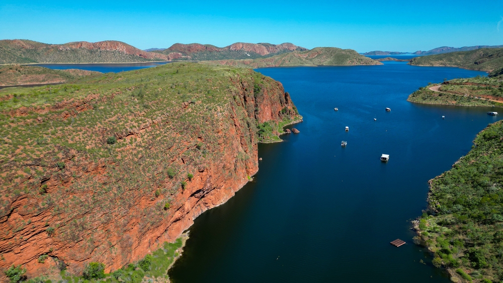
Lake Argyle
Crossing into Western Australia, the character of the Savannah Way transforms yet again. The Kimberley is dramatic on a scale that surprises even seasoned Australian road trippers.
Kununurra is a well-serviced town surrounded by extraordinary landscapes. Nearby Lake Argyle – one of Australia's largest artificial freshwater lakes – is a popular detour for its wildlife, scenic cruises and vast inland waterways. The Ord River Irrigation Scheme has transformed this remote region into a productive agricultural area, creating a striking contrast between red rock country and lush green farmland.
Before crossing into Western Australia, check current state biosecurity rules for fruit, vegetables, plants, honey and other regulated items.
Heading south-west, Fitzroy Crossing provides access to Danggu (Geikie Gorge) National Park, where the river once carved dramatic cliffs into the ancient reef limestone. It makes a timely stop for fuel and supplies before continuing west, but check current park alerts before visiting, as access and facilities can change seasonally.
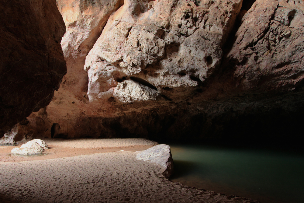
Tunnel Creek
Derby is the next significant town, with access to Bandilngan (Windjana Gorge) and Dimalurru (Tunnel Creek) in the 350-million-year-old Napier Range for travellers with suitable off-road vehicles. Even for those staying on sealed roads, Derby has a rich history, and the famous Prison Boab Tree – with a trunk circumference of around 14 metres – sits just outside town.
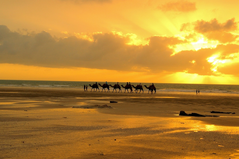
Camels, Cable Beach
The route finishes in Broome, one of Australia's most iconic coastal towns. Cable Beach, the town's pearling heritage, Sun Pictures outdoor cinema and the extraordinary Staircase to the Moon phenomenon (in season) make it a fitting end – or beginning of a Cairns to Broome road trip.
Towing a Caravan on the Savannah Way
Some parts of the Savannah Way are straightforward with a caravan. Others are not. The sealed sections are usually the easier option, while the rougher stretches and side roads can be hard on a standard touring van. Before heading off, check the road ahead and be honest about what your caravan and tow vehicle can handle.
Which Sections Suit Conventional Caravans?
Conventional touring caravans are generally better suited to sealed highways and routes with reliable services. Narrow sealed roads, damaged edges and maintained gravel sections still require slower speeds and careful assessment. Do not assume that every road shown as part of the Savannah Way is suitable for an on-road caravan.
When Is a High-Clearance or Off-Road Setup Recommended?
High clearance or purpose-built off-road capability may be required for corrugated remote roads, creek crossings and some national park or gorge detours. Suitability should be confirmed against current conditions, the vehicle and caravan specifications, and insurance restrictions.
Remote Travel and Towing Checklist
Before leaving the sealed route, take a few minutes to work through the basics:
- Check the latest road reports instead of relying on older trip notes.
- Make sure both the caravan and tow vehicle are suitable for the surfaces ahead.
- Read the fine print in your insurance policy, especially for unsealed roads.
- Work out your fuel range and leave room for detours or closed fuel stops.
- Carry more drinking water than you expect to use.
- Check tyre condition and pack the right spares and repair gear.
- For isolated sections, take a UHF radio, a satellite communicator, or a personal locator beacon.
- Give road trains plenty of room and avoid rushing to overtake.
- Slow down on corrugations and secure anything that could shift inside.
- After rain, ask locally before continuing onto remote or poorly graded roads.
Match the Route to Your RV
A road that suits one caravan may not suit another. A conventional touring caravan may be comfortable on sealed highways but less suitable for corrugated or poorly maintained roads. Semi-off-road and off-road models may offer greater clearance and stronger construction, but that does not make every remote track suitable for them.
Before taking an unsealed detour, check the vehicle manufacturer’s limits, your insurance conditions and the latest road advice. Ground clearance, tyre condition, weight, creek crossings and recent rain can all change whether a route is practical.
When is the Best Time to Drive the Savannah Way?

Fitzroy River
April to October generally offers the most reliable conditions for a Savannah Way road trip. Temperatures and humidity are usually more manageable, and many parks and tourism services operate through the dry season. June to August is the busiest period, so book popular caravan parks and campgrounds early, especially around Katherine, Kununurra and Broome. Travel from November to March can be disrupted by heavy rain, flooding, creek crossings and road or park closures. Even during the dry season, access can change due to prior weather damage or maintenance. Check official road and park reports before departure and throughout the journey.
Frequently Asked Questions
How far is the Savannah Way from Cairns to Broome?
The Savannah Way is approximately 3,700 kilometres from Cairns to Broome. Exact distances will vary depending on detours and where you start and finish in each city.
How long does it take to drive the Savannah Way?
Most drivers allow 14 to 21 days for the full route. If you want time to properly explore parks, fishing spots, gorges, and outback towns, allow for three weeks. Driving the route in less than two weeks means missing a lot of what makes it worthwhile.
Can I tow a caravan on the Savannah Way?
Yes, but not every section will suit every caravan. The sealed route is the simpler option for many touring setups, while some unsealed roads and side trips may be rough, narrow, or better suited to a 4WD or an off-road van. Check the latest conditions, your vehicle limits and fuel range before setting out.
What is the best time to travel the Savannah Way?
April to October is the recommended travel window. The dry season gives the most reliable road conditions, particularly on unsealed sections, and makes creek and river crossings safer. June to August is the busiest period, so book ahead.
Can you drive the Savannah Way from Broome to Cairns?
Yes. You can travel the Savannah Way in either direction. Starting in Broome simply reverses the order of the stops, but you will still need to plan around fuel, water, road access and the time of year.
Is the Savannah Way fully sealed?
No. The Savannah Way includes sealed roads, narrow sealed sections and potentially unsealed remote roads, depending on the route chosen. Some longer alternatives allow travellers to remain predominantly on sealed highways.
Do you need a 4WD for the Savannah Way?
Not for the whole trip. The mostly sealed options may suit a two-wheel-drive vehicle, while rougher sections and some national park detours can require extra clearance or four-wheel drive. Check each part of your route rather than assuming one vehicle will suit the entire journey.
Where should I check Savannah Way road conditions?
Check Queensland Traffic, the Northern Territory’s official road-condition service and Main Roads Western Australia. Recheck conditions at major towns because flooding, roadworks and park access can change during the trip.